The reason for this is the complex nature
of the coastline; its peninsulae, headlands, bays, promontories,
estuaries,
inlets and coves. With very few exceptions, involving the avoidance of
quarry works, military bases and landslip sites, the path hugs the
coastline
throughout. It's a walk of contrasts; the scenery varies from the
dramatic
granite clifftops of the Atlantic coast to the bustling seafront
promenades
of towns such as Penzance. Much of the coastline is owned by the
National
Trust; the vast majority of it is undeveloped. There are cliffs and
coves,
downs and pastures, picturesque villages, beaches both popular and
unfrequented,
natural wonders and industrial relics, and the odd tourist trap such as
Mevagissey, Polperro and Looe.
A car is a liability rather than an aid to a linear walk such as this, primarily because you have to return to your car once the walk is over. All starting and finishing points that I have suggested are served by public transport although services can be rather skeletal here and there, and sometimes it's necessary to walk a mile or two off route to find a bus stop. If, like me, you enjoy the comforts of a guest house or cheap hotel room, then consider basing yourself in convenient towns and tackling three or four days walks from each by using public transport. Suitable transport hubs include Penzance, Helston, Falmouth, St Austell, Looe and Plymouth.
Route finding is straightforward almost everywhere. The path is very well waymarked and in any case the route is obvious most of the time - as Mark Wallingford says in his book, "500 Mile Walkies", you just keep the green bits to your left and the blue bits to your right. In wet weather, of course, you keep the brown bits to your left and the grey bits to your right - but do you honestly want to be out there in the rain? The only places where you're likely to go wrong are when trying to find the correct route out of towns and villages. Keep a guidebook with you and refer to it often.
Bear in mind that most of the route is on uneven ground and that some of it is in close proximity to cliff edges. For this reason it's unwise to venture out in wet weather. The climate can be fickle; apart from wind and rain, sea-fog is another potential hazard. Don't underestimate the effort involved; there is a lot of ascent and descent involved and some sections can be very tiring. Keep the daily mileage down until you are sure of your capabilities.
The number of villages and small towns on route ensure that you're usually not far from shops, cafes, toilets and other useful amenities. There are some sections, in fact, where it's not really necessary to carry food with you. But you should always carry plenty of fluid, particularly on warm days.
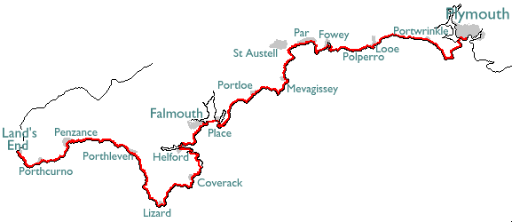
| 1 | Land's End to Porthcurno | 5.5 miles |
| 2 | Porthcurno to Penzance | 11.45 miles |
| 3 | Penzance to Porthleven | 13.3 miles |
| 4 | Porthleven to Lizard | 13.54 miles |
| 5 | Lizard to Coverack | 10.26 miles |
| 6 | Coverack to Helford | 11.15 miles |
| 7 | Helford to Falmouth | 9.8 miles |
| 8 | Place (via ferry) to Portloe | 13.5 miles |
| 9 | Portloe to Mevagissey | 11.92 miles |
| 10 | Mevagissey to Porthpean | 6.68 miles |
| 11 | Porthpean to Fowey | 11.3 miles |
| 12 | Fowey to Polperro | 7.36 miles |
| 13 | Polperro to Looe | 5.07 miles |
| 14 | Looe to Portwrinkle | 7.8 miles |
| 15 | Portwrinkle to Plymouth | 15.5 miles |
| Back to main index | Devon Coast-to-Coast |
Page updated 2 November 2011
![]()