![]()
![]()
![]()
Back to Landscape Photography homepage
The Concept
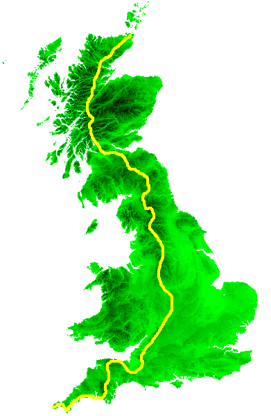
On 1st April 1988 I set out from Malham in North Yorkshire to walk the Pennine Way, in sections. The walk grew, linking together a series of British long-distance footpaths. At 7pm on 29th May 2004 I arrived at the Inchbae Hotel, Easter Ross, thereby completing a contiguous series of hikes from one end of Britain to the other - Land's End to John O' Groats. Altogether I had walked 1393 miles.
I planned the walk as the Americans would call a section hike - a bit at a time, a day or two here, a weekend there, not necessarily in sequence, gradually linking the long series of day walks into one continguous whole. I though that the Pennine Way would take me five years but it took just three, and by the spring of 1990 I was already wondering how to follow it up. The West Highland Way was an ideal choice for scenic beauty, but on the other hand the Cotswold Way looked like an easier option. It was while researching the choice of footpaths that I discovered others that were linked together - where the Cotswold Way ended, the Heart of England Way began, and that in turn connected to the Staffordshire Way at Cannock Chase. I realised that the Staffordshire Way ended not far short of the Pennine Way, and I wondered if there was a route that would connect the Pennine Way in turn to the West Highland Way Before I knew it I'd hatched a plan to walk from Land's End to John O'Groats, one extremity of Britain to the other. It would be done mainly on recognised long-distance paths, but where these didn't exist I'd make up a route of local footpaths or (in Scotland) forest tracks and estate roads. I made one or two wild dog-legs and diversions, mainly in the south west to include Dartmoor, Exmoor, the Quantocks and the Mendips in the route. Altogether the distance came to around 1378 miles (since revised.)
My chosen route keeps as far as possible to the best of Britain's scenery; mountains, moors, hills, forests, pastures and clifftops, and nowhere is it technically difficult. Maybe I'll inspire you to try it yourself. I don't expect that anyone will follow the same route - the sequence of paths described here is full of my own preferences and quirks and you'll no doubt have your own. Many people have waked from Land's End to John O'Groats, for many reasons and by many different routes. Few accounts have been published but it does seem that most went by road. I did it the hard way and took my time, but after all it was a labour of love.
Other walkers have inspired me and I have based parts of my route on theirs; particularly Hamish Brown (whose Pennine to Highland route forms most of my South of Scotland Way) and Laurence Main (on whose Somerset Way I based my own).
| South Cornwall Coast Path | Land's End to Plymouth | 15 days | 154.03 miles |
| Devon Coast to Coast | Plymouth to Minehead | 10 days | 112.17 miles |
| A Somerset Way | Minehead to Bath | 9 days | 111.54 miles |
| The Cotswold Way | Bath to Chipping Campden | 9 days | 103 miles |
| Heart of England Way | Chipping Campden to Rugeley | 6 days | 88 miles |
| Staffordshire Link | Rugeley to Thorpe |
3 days | 27 miles |
| A White Peak Way | Thorpe to Edale | 4 days | 34.9 miles |
| The Pennine Way | Edale to Kirk Yetholm | 23 days | 253.2 miles |
| A South of Scotland Way | Kirk Yetholm to Milngavie | 13 days | 143 miles |
| The West Highland Way | Milngavie to Fort William | 8 days | 95.7 miles |
| A Great Glen Way | Fort William to Cannich | 5 days | 54½ miles |
| North of Scotland Way | Cannich to John O'Groats | 14 days | 184½ miles |
News Update, 25th November 2010:
Updates have been very slow over the past three years and it must seem to all my regular readers as though this site has ground to a halt. The truth is that I've had other priorities; in September 2005 my dad suffered a heart attack, and even as he was lying in the recovery ward in Bedford hospital my mum was diagnosed with cancer. As their health deteriorated I had to put leisure and hobby activities aside and act as full-time carer for them both. The crisis came to a head during 2010. I was made redundant in January. Dad died in March, and I lost Mum at the end of August after months of continual and horrendous suffering. Her passing was a happy release.
Matters having been resolved, therefore, I am free to persue a normal life and I expect to resume hiking, hillwalking and photographing activities in 2011.
Work on the end-to-end walk will continue. Route revisions are being made, work on the website itself is still in progress and I want to rewalk sections of the route - as weather and opportunity allows - to bring the patchy photographic record up to a consistent high standard.
Another route change is in the offing. I've discovered the existance of the Macmillan Way, the Samaritans Way and the West Deane Way, a combination of which will almost certainly provide a superior route on the Dunster - Bicknoller and Bicknoller - Taunton sections of the Somerset Way. In many places these trails are either coincident with or run close to my present route. It's unlikely that I will be able to explore these alternatives in the short term but once matters are resolved I hope to be out on the trail again.
'm embarking on a complete remeasurement of
the route. This has been made possible by the aquisition of some
digital mapping software (www.memory-map.co.uk).
I
have
started to add "walk statistics" tables to walks for which I
have map data available, showing distance walked, net ascent, net
descent and time taken. I shall also be able to add route profile
diagrams in due course. It has become apparent that the various route
distances given in guidebooks are inaccurate, sometimes by more than
two miles per walk; it's likely that the aggregate distance of the
End-to-End will drop by around twenty to thirty miles as I remeasure
it. I'm aiming to complete this remeasurement before the end of 2011.
| Sept 3rd 2008 |
Wells to Cheddar |
Repeat walk, new photos |
| May 30th 2009 | Rugeley to Abbots Bromley |
Repeat walk, new photos |
I am currently adding images as quickly as possible, and am no longer constrained by webspace limitations. I have to admit that when I started to build this site I didn't really appreciate what I was taking on; its construction is proving far more time-consuming than I'd like. Please bear with me - it'll continue to grow.
In the meantime, enjoy the walks!
John A Butler, Biggleswade, Bedford, England.
All images on this site are the copyright of the author. You may download and archive them; you may use them as wallpaper or backdrops; you may alter and manipulate them for your own amusement.
You may not use them for commercial gain. You may not pass them off as your own. If you wish to include any of these images on your own website, or otherwise place them on the internet in any way, you are required to contact the author first for permission. Original credit and a copyright notice will be a manditory condition before such a request is granted. If you derive any new image wholly or partially from them such as a manipulation or composite, and you wish to publish any resulting image or use it for commercial gain, you are similarly required to contact the author for permission, and to give original credit, and to append a copyright notice to any such image.
Page updated 2 November 2011
![]()