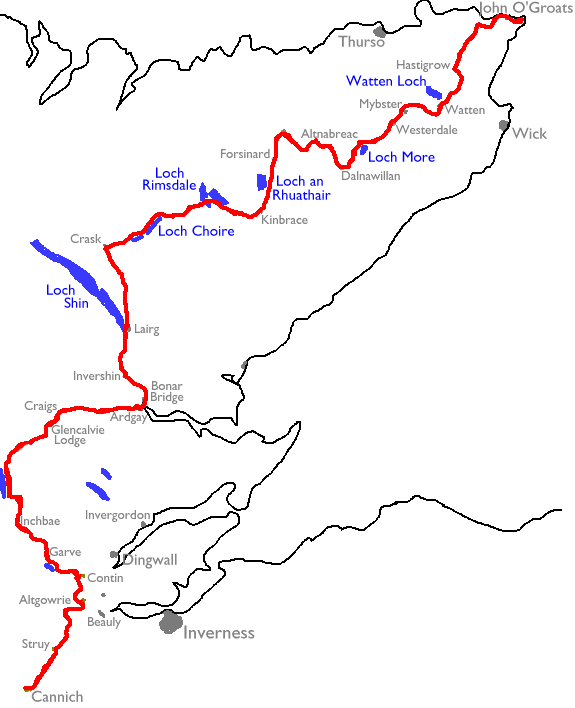
The route has already changed substantially from that which I originally drew up. It commences at Cannich, in Inverness-shire, and adopts what were formerly the last 3 days of the Great Glen Way. It heads up Strath Glass to Struy, then takes the Orrin Dam hill track into Glen Gowrie and a series of local paths (mainly through the Fairburn estate) around the edge of the Beauly and Cromarty firths. At Contin we head through the Torrachilty Forest and the Blackwater gorge to Garve, then by forest paths to Inchbay. From here a series of estate paths pushes through remote, empty country; Strath Rannoch, Strath Vaich, and Gleann Mor bring us to Glencalvie Lodge, then the public road along Strath Carron leads us to Ardgay on the south side of the Dornoch firth. We cross here to Bonar Bridge.
Back lanes and forest tracks lead along
the
north side of the Firth to Invershin, from where more forest tracks and
unavoidable stretches of main road take us to Lairg. Another day of
road
walking takes us to the lonely inn at Crask. From here a track leads
eastwards
to Loch Choire, from where an estate road and public road lead out to
Kinbrace
station. The main road must be used as far north as Forsinain, from
where
a small maze of forest tracks - the only viable route across the marshy
ridge that is the Flow Country - heads towards the railway halt at
Altnabreac.
From here a track leads to Dalnawillan Lodge from where an estate road
leads out along the valley of the river Thurso to Westerdale. Finally,
two days of road walking among this strange, stilted countryside leads
to the north coast of Scotland and to John O'Groats, the northwestern
tip
of Britain, and journey's end at last.
Important note, June 2010:A correspondent who recently walked the route tells me that two significant obstacles have cropped up, affecting walks 3 (Altgowrie to Contin) and 4 (Contin to Inchbae). He writes:1. The route across the dam at the base of Loch Achonachie between Muirton Mains and Torachility (NH446545) is to be closed permanently from 1 June 2010 'for health and safety reasons'. The fence has already been constructed with large gates, and we were fortunate we arrived on 28 May! No other obvious alternative exists other than the road at Moy bridge. 2. The footbridge across the Blackwater river exiting Longart Forest near Inchbae Lodge has been demolished by the Forestry Commission 'for health and safety reasons' and is not being replaced. Again no alternative exists - we waded the river, which with 50lb rusksacks was not very safe, but the alternative 10ml down and back up the road (we were staying at Inchbae) was also unthinkable at the time. The closing of the Loch Achonachie dam to walkers is a real blow and for the present walkers will need to use the road bridge at Moy Bridge (direct along the road from Altgowrie) and thence alongside the main road to Contin. This is very unsatisfactory indeed and I will need to research whether any alternatives exist. The removal of the vehicle bridge at the exit from Longart Forest is an even bigger blow in the short term - the Forestry Commission have stated their intent to substitute a footbridge here at some future date, but for now it seems that there is no alternative to walking alongside the busy main road all the way from Silver Bridge to Inchbae. |
| 1 | Cannich to Struy | 8 miles |
| 2 | Struy to Altgowrie | 10½ miles |
| 3 | Altgowrie to Contin | 6 miles |
| 4 | Contin to Inchbae Hotel | 13 miles |
| 5 | Inchbay Hotel to Glencalvie Lodge | 20 miles |
| 6 | Glencalvie Lodge to Ardgay | 10 miles |
| 7 | Ardgay to Lairg | 14 miles |
| 8 | Lairg to Crask Inn | 13 miles |
| 9 | Crask Inn to Kinbrace | 25 miles |
| 10 | Kinbrace to Forsinard | 7½ miles |
| 11 | Forsinard to Altnabreac | 15 miles |
| 12 | Altnabreac to Westerdale | 14½ miles |
| 13 | Westerdale to Hastigrow | 13 miles |
| 14 | Hastigrow to John O'Groats | 14½ miles |
| Great Glen Way | Back to main index |
This page last updated 12th June 2010
![]()