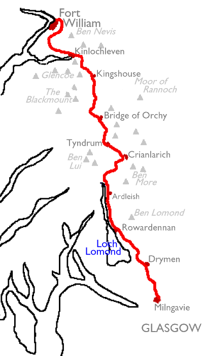
The path is not difficult, and veterans of the Pennine Way will be almost astonished at the relative ease with which this route can be walked. Most of the path lies along good vehicle tracks, a mixture of estate roads and forest drives. Only along the east bank of Loch Lomond north of the Rowardennan Hotel does the route degenerate into a rough path, and the only ascent worthy of note is that of the Devil's Staircase (the ascent to the ridge eastwards of the Aonach Eagach) immediately northwest of Kingshouse.
The West Highland Way starts innocuously in what is, in effect, a suburb of Glasgow and the first day and a half's walking is unremarkable. However, once you reach Loch Lomond and cross the Highland Boundary Fault things change dramatically. The Highlands rise on both sides of Loch Lomond and you have the option of ascending Ben Lomond, Scotland's southernost Munro (mountain over 3000 feet) from Rowardennan. North of Loch Lomond the rough path joins a good landrover track at Ben Glas farm and then follows the banks of the river Falloch, with the heights of Ben Dubhcraig rising to the northwest. As the head of Glen Falloch is reached the path crosses the main A82 road to the western side, following another landrover track past the lonely farm of Kellator into the forest plantations above Crianlarich. Here the route enters the drainage system of the river Tay and turns northwest into Strath Fillan. The forest paths give good walking most of the way to Tyndrum before the path drops to the road. A couple of farm tracks are followed and then the Way hops back over the road to reach Tyndrum alongside the Oban branch of the West Highland Railway.
Beyond Tyndrum the Way follows the route of the old road northwards, running parallel with the Fort William branch of the West Highland line. Both routes run around the foot of the mountains of Beinn Odhair and Beinn Dorain, the walking route on a good landrover track throughout, to reach the railway halt and hotel at Bridge of Orchy. Beyond here the Way branches off through another forest plantation and rounds the western end of Loch Tulla to enter the Forest Lodge estate. The old drove road that is now followed enters what is arguably the most scenic stretch of the entire End-to-End walk - the Blackmount, where the peaks of Stob Ghabhar, Beinn Toaig, Clach Leathad, Meall a' Bhuiridh and Creise rise dramatically to the right while the wastes of Rannoch Moor stretch away to the left. Beyond the scenic gems of the Blackmount and the river Ba, the path rises to a shallow col beyond which lies the dramatic grandeur of Glencoe.
The path runs down by the Glencoe ski-lift at White Corries to the old coaching inn at Kingshouse. From here it runs along the route of another old road into the mouth of Glencoe itself, where the twin sentinels of Creise and the Buachaille Etive Mor guard the entrance to Glen Etive. The path climbs the opposite ridge by a track called the Devil's Staircase, before descending by a rather gentler gradient to the unlovely town of Kinlochleven, home of the British Aluminium Company's smelting plant. The path climbs again now, doglegging up to the old military road alongside the Allt Nathrach (stream of the snake), there to pass southwards of the mighty Mamores. This wild, silent pass opens up to the north to reach Lochan Lunn da Bhra, from where a forest path hops over a col to the northeast to come down into Glen Nevis and the end of the Way. Alternatively, a motor road from the same point will take you via Blarmachfoldach and Auchintore into Fort William direct.
The most frustrating aspect of the Way is that it is just too long to be walked comfortably in a week. The walk as described has a couple of shorter sections but the logistics involved in dividing the whole Way into seven roughly equal sections, with an overnight stop at the end of each, are pretty formidable.
The guidebooks are full of the usual warnings about equipping yourself with adequate clothing and footwear and carrying a map and compass. I concur wholeheartedly with the first of these warnings, as the weather becomes ever more fickle as you move north and you're liable to get rained on in the western Highlands even more so that in the Pennines. The second warning is, however, rather superfluous in my view. There is no pathless terrain on the West Highland Way and you aren't going to get lost. You needn't even carry a map, strictly speaking, though personally I would feel naked without one as they are such a useful general reference and are every bit as valuable, if not more so, as a good guidebook. You should carry plenty of food and liquid with you as refreshment stops are almost unknown (there is just one that I am aware of, at Ben Glas farm at the northern end of Loch Lomond. You might also consider the cafe at the White Corries chairlift if the bar at Kingshouse doesn't appeal).
If you are walking in July, August or September, beware the midges. These small, mosquito-like biting insects are harmless but are a major irritant and tend to swarm in their thousands. You may find yourself driven from otherwise ideal wild campsites because of these pests. August and September also mark the shooting and stalking season and you are advised to take heed of any notices asking you to stick to prescribed routes. The official route of the Way is not affected by these restrictions but you may find that any off-path expeditions you had planned, particularly climbs in the Blackmount, could be frustrated.
| 1 | Milngavie to Drymen | 12 miles |
| 2 | Drymen to Rowardennan | 14.3 miles |
| 3 | Rowardennan to Ardleish | 11.6 miles |
| 4 | Ardleish to Tyndrum | 14.2 miles |
| 5 | Tyndrum to Bridge of Orchy | 6.7 miles |
| 6 | Bridge of Orchy to Kingshouse | 12 miles |
| 7 | Kingshouse to Kinlochleven | 8.9 miles |
| 8 | Kinlochleven to Fort William | 16 miles |
| South of Scotland Way | Back to main index | Great Glen Way |
This page last updated 21st December 2006
![]()