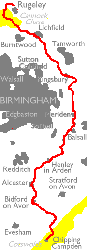
Despite its proximity to the cities of
Birmingham
and Coventry the character of the walk is almost entirely rural. The
country
you pass through is prediminantly farmland, though its charachter
changes
subtly as you walk northwards. The Way leaves the diminishing Cotswold
scarp at Meon Hill to fall to the Vale of Evesham and its orchards and
vegetable fields, reaching the river Avon at Bidford. Flattish country
of cropped fields and little villages then gives way to the hillier
Arden
landscapes, dotted with woods and pastures. Grazing sheep give way to
grazing
cattle and then more crops, broken briefly by the Coventry suburbs of
Balsall
Common and Berkswell. Some splendid open country follows as you cross
the
low hills around Meriden, the geographical centre of England. The Tame
valley beyond is a post-industrial landscape, a world of water parks
created
from disused gravel pits, with vistas of motorways, power stations and
electricity transmission lines. Fortunately this section is brief, a
series
of wooded hills around Weeford being followed by the vast, prairie-like
fields of Packington Moor and the small cathedral city of Lichfield.
And
after Lichfield comes Cannock Chase, a world of wooded heathland and
long,
straight vehicle tracks much loved by cyclists. The Heart of England
Way
links up with the Staffordshire Way on Cannock Chase just west of
Rugeley,
and in consequence the last section of the walk described here actually
extends onto the latter route in order to reach the closest approach to
the town.
It's good public transport country,
though.
Every obvious start and finish point is within about an hour of
Birmingham
New Street, making the Way ideal for tackling as a series of day hikes.
If the prospect of basing yourself in Birmingham doesn't enthuse you,
consider
staying in other, more aesthetic locations - I found that
Stratford-on-Avon
was an excellent base for the southern half of the Way, while Lichfield
itself served the northern half adequately. You do need to check on
public
transport times on Sundays and bank holidays, and remember also that
the
Midland Main Line - serving Rugeley and Lichfield Trent Valley - has a
surprisingly skeletal service even on weekdays. Some journeys will
involve
travelling into Birmingham and out again, but that's no real hassle.
| 1 | Chipping Campden to Bidford-on-Avon | 13½ miles |
| 2 | Bidford-on-Avon to Henley-in-Arden | 11½ miles |
| 3 | Henley-in-Arden to Berkswell | 12½ miles |
| 4 | Berkswell to Kingsbury | 16½ miles |
| 5 | Kingsbury to Lichfield | 13½ miles |
| 6 | Lichfield to Rugeley | 20.6 miles |
| Cotswold Way | Back to main index | Staffordshire Link |
This page last updated 21st February 2006