| Langport to Street | Back to Somerset Way index | Wells to Cheddar |
| Langport to Street | Back to Somerset Way index | Wells to Cheddar |
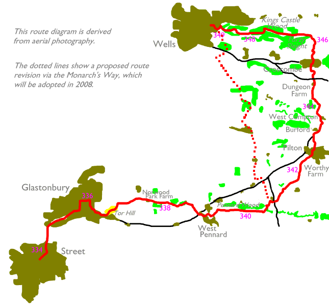
Unusually, the route involves three significant towns in one day. We start at the shoe manufacturing town of Street, and then go straight to Glastonbury, a place swamped in myth and legend and apparently the spiritual home of half of Britain's ageing hippies. There are no footpaths and unfortunately it's necessary to walk from Street to Glastonbury along the main road. The third and final town is the splendid city of Wells; the cathedral and its environs are a gem and the town centre is a place of charm and character. Between Glastonbury and Wells we traverse some twelve miles of mixed farmland and woodland, visiting the isolated topknott of Tor Hill and passing close to Worthy Farm - site of the biannual Glastonbury Music Festival.
Map: OS 1:25000 Explorer 141 (Cheddar Gorge & Mendip Hills West)
Click on any thumbnail image in this gallery to display the corresponding full size image. The images are access protected through a cgi script to prevent hotlinking. If you encounter problems while trying to view the full size images, please read the access advice page.
Note: The
images as far as Dungeon Farm are an "interim" set and will be replaced
by better
photographs
at some future date.
![]() First
Badgerline service 376/377, Somerton
- Street - Glastonbury - Wells - Bristol
First
Badgerline service 376/377, Somerton
- Street - Glastonbury - Wells - Bristol
![]() First
Badgerline service 163, Bridgwater
- Street - Glastonbury - Wells
First
Badgerline service 163, Bridgwater
- Street - Glastonbury - Wells
![]() First
Badgerline service 669, Shepton
Mallet - Pilton - Glastonbury - Street
First
Badgerline service 669, Shepton
Mallet - Pilton - Glastonbury - Street
Walk northeast from the town centre to a crossroads (probably a roundabout now) in an industrial area near the edge of town, and take the road leading half left (north) out of town for 700m, where you will reach a roundabout and join the main A39. Continue along the main road to the north, where after 500m you cross the river Brue. Glastonbury itself is hidden by the low ridge of Wearyall hill, which lies within its south western suburbs. 300m on from the bridge you reach the south western extremity of Glastonbury.


Views from Wearyall Hill: back towards Street; south eastwards along the Brue valley; eastwards to Tor Hill
You've reached the western end of Wearyall Hill and it's worth climbing, both for the view and to get the feel of grass under your feet for the first time today. The hill is of modest height (probably about 75m or 250ft) but since most of the surrounding terrain is flat there is rather a good panorama. Both Glastonbury and Street are well seen of course, and your eyes are drawn irresistibly to the isolated hillock of Tor Hill and its ruined church tower a mile to the east. Look to the north and northwest also, for there you will see the dark line of the Mendip Hills along which tomorrow's route lays. Walk all the way along the ridge but towards the east end find a path heading diagonally down to the road to the northeast, just short of the first houses.


Glastonbury from Wearyall Hill; view northwest towards the Mendips; Glastonbury town centre
Once you come down to the road walk east to a road junction, then turn left and walk north for about 600m to Glastonbury town centre.
![]() First
Badgerline service 376/377, Somerton
- Street - Glastonbury - Wells - Bristol
First
Badgerline service 376/377, Somerton
- Street - Glastonbury - Wells - Bristol
![]() First
Badgerline service 163, Bridgwater
- Street - Glastonbury - Wells
First
Badgerline service 163, Bridgwater
- Street - Glastonbury - Wells
![]() First
Badgerline service 669, Shepton
Mallet - Pilton - Glastonbury - Street
First
Badgerline service 669, Shepton
Mallet - Pilton - Glastonbury - Street
Glastonbury is a charming little town, though it does carry the baggage of a great deal of myth and legend. It is supposedly the Isle of Avalon, home and resting place of King Arthur. Joseph of Arimathea was said to have visited the town, and to have plunged his staff into the ground where it grew into a thorn bush that allegedly flowers every Christmas day. The Holy Grail is said to have been buried at Chalice Well, at the foot of Tor Hill. The church on Tor Hill was struck by lightning some centuries ago and all was destroyed but the tower, an apparent sign of divine intervention. A number of ley lines cross at Glastonbury. Thanks to the weight of legend half the mystics, new-age followers and ageing hippies in Britain have gravitated to Glastonbury, where they have set up businesses selling crystal balls, joss sticks, tarot cards and secondhand Grateful Dead albums to the other half.
If you're into all this stuff you already know about Glastonbury (and perhaps you live there). If you're not, you may well shake your head in disbelief. All that stuff you think you know about King Arthur - Camelot, Merlin the wizard, Lancelot and Guinivere, Excalibur, et all - is fiction. Arthur is fiction. He never existed, at least not as a monarch - most likely the legends that have grown around his name stem from ancient Welsh writings and probably refer to a local warlord. All the other stuff of Arthurian legend has gradually evolved in various retellings and rewritings. Look through any standard list of the Kings and Queens of England. Do you see King Arthur listed? Well, then. There are varieties of thorn bush that flower in midwinter. Those of us with a rudimentary knowledge of the forces of nature realise that lightning has a natural affinity for tall structures and isolated hills. Consider also that those who plot ley lines base them on places such as Glastonbury, so the fact that several of them cross here is perhaps the most transparent circular argument ever advanced.
Shorn of all this baggage Glastonbury is still a charming place, worth a look round at leisure. So look and wonder, or look and laugh, but do look. From the town centre our route goes east to the next main road junction, then south towards Tor Hill, and thus goes around three sides of the old Abbey grounds - worth a visit if you have time, though of course today's walk is a long one. At the next road junction a narrow lane goes off slightly south of west, from where a footpath heads directly up the east side of Tor Hill.
![]() Glastonbury
On Line
Glastonbury
On Line
![]() Glastonbury
Abbey
Glastonbury
Abbey
![]() Glastonbury,
alternative
guide
Glastonbury,
alternative
guide


Tor Hill is 158m, or about 520ft, above sea level; and since the surrounding Somerset Levels are pretty much at sea level anyway the hill stands out starkly from the surrounding landscape. Its position gives it a commanding view across much of this corner of Somerset; the western panorama includes the Quantocks and most of the country we've walked in the last two days, so it is really surprising that the Tor wasn't seen from anywhere on the walk until just the other side of Street yesterday. The panorama takes in Street, Glastonbury and Wells (it should be easy to spot the cathedral from up here), and the white tower of the Mendip TV mast will also be prominent (and will remain so until we're well north of Bath in four days' time). To the south and southeast are the hills around Somerton and Yeovil; to the northeast is Shepton Mallet, and directly to the east is our next immediate objective, the hill beyond West Pennard three miles away.


Wells and the Mendips; Street; Glastonbury

Glastonbury from the tower

view towards Somerton hills
There's a viewpoint indicator around thirty metres northeast of the tower, and it's worth studying provided that it isn't being sat on by a bunch of misty eyed Yogic meditators. Once you've experienced all of Tor Hill that you need to, walk off to the northeast on the obvious path to reach the road. Follow this road to the east, dodging the parked cars, as far as Norwood Park Farm.
From this confluence continue in the same
direction for 200m, then once you come alongside another drainage ditch
go slightly right and head for East Street Farm. The right of way kinks
left again at a stream crossing to pass just to the left of East Street
Farm. From here another footpath is shown heading southeastwards to
West
Pennard direct, diagonally across pastures, but it would be more
rewarding
(particularly if you had trouble following the path thus far) to stick
to the farm drive and the little lane out to East Street. The lane
turns
right to come out onto the A361 road at the edge of West Pennard.


Tor Hill from West Pennard
I remember West Pennard as a neat and sleepy little place. The map shows a grid of footpaths east of the village, and your next destination is the top of Cottle Lane, so there are many combination s of path you could take to get there. My favoured variant is to walk from the East Street lane junction along the road to the main village crossroads, and turn right; after 200m find a footpath to the left and follow this along a field boundary for 250m. Now turn right onto a path heading generally southeast for 150m, then go left again for a path heading uphill, for a further 200m. A continuation of this path continues uphill and merges with Cottle Lane, but there's better scenery to be had a little way south. Take the path southeast for about 300m, behind the village school, then take a track to the left going uphill. In 150m this diverges into three rights of way. Follow the one going half left, going diagonally up the steep slope of Pennard Hill. If you take a look behind you will see a splendid retrospective view across the village towards Tor Hill. Keeping a careful eye on the map, follow the field boundaries up to a junction of four footpaths with Cottle Lane.
Our route pretty much follows the ridge of Pennard Hill for the next mile but the right of way - which you will see heading due east - proved difficult to follow when I walked this section in 1994. Follow the lane until it peters out some 600m beyond the path junction referred to above. The right of way continues in the same direction, while from the same point a more obvious path goes off half right to join a road at a bend. If you continue straight on you will cross this same road about 250m north of this bend, from where the right of way is meant to continue due east across fields and pastures for a further 800m. In 1994 it was blocked by hedges and fences and I was forced to retreat to the road looping 300m to the south. It will require a further visit to discover if the situation has improved, or perhaps anyone with local knowledge who reads this might like to get in touch with an update.
Road and right of way converge by a lonely road junction on the brow of the slopes above Sticklinch Farm, and there's a fine view to the north from here; probably as good a place as any to stop for lunch. You can either walk down Castle Lane or try your luck on the footpath heading diagonally down the slopes some 200m to the west. This footpath is the preferred route and crosses Castle Lane about 200m short of Manor Farm. The footpath continues along the slope to cross Sticklinch Lane and then turns half left to head across pastures to Holt Farm, but you may find it more straightforward to go by road and approach Holt Farm along its driveway from the west.

Holt Farm and Pilton from the slopes adjacent to Castle Lane
![]() The Glastonbury
Festival website
The Glastonbury
Festival website
At the Pilton Park track junction the path swings half right but can still be difficult to follow, not least because there are some vehicle tracks in the vicinity that the map doesn't show. Head slightly east of north, tending uphill, and head for the southwest corner of a ribbon of woodland. The path follows the southern edge of this wood, initially just inside the fence. Continue along a little way past the other end of the wood to converge with the lane at Pilton.

Pilton village centre
![]() First
Badgerline service 669, Shepton
Mallet - Pilton - Glastonbury - Street
First
Badgerline service 669, Shepton
Mallet - Pilton - Glastonbury - Street
Pilton is lovely. Haphazard, timeless, charming, it seems to belong in another century and one wonders how it copes with the summer invasion of festivalgoers every second year. If you want to break the journey here there is a bus service between Glastonbury and Shepton Mallet. I'm sure there's a pub or two here and you might get a pub lunch, but I don't recall any shops in the village.
Our next objective is Burford Cross, half a mile to the north. You can go by road or by footpath. the footpath is the more elegant alternative and you will see it leaving from the main A361 about 300m east of the main village crossroads. It's fun finding your way through the maze of little lanes and residential roads in the village. The preferred route should be obvious from the map, but for the record go hard left where you first reach the road at the end of the footpath from Pilton park; follow the lane as it winds right and then left past the church; take a right turn at a staggered junction and follow this lane left, right, right and left out to a junction with the main road; turn right and follow the A361 for 200m and then turn left onto the path to Burford Cross.

Burford
From Burford Cross take the lane northeast to Burford and West Compton. Burford itself is a dream of a place; three palatial mansions built of what looks very much like Cotswold stone, strung out in a line. Immediately beyond Burford there is a cross field path to West Compton. On paper it's the most elegant route, but in 1994 it was thoroughly and irrevocably blocked so don't waste your time. Follow the lane and go to West Compton by road.

West Compton from Burford
Walk through West Compton and out to the northwest, past Brook House Farm. About 250m beyond the village you reach a lane junction. Take the footpath going north northeast from here, which runs uphill through a narrow pasture. At the top end of the pasture turn half left for a right of way heading to Dungeon Farm. This is, although tricky to navigate, more straightforward than many of today's footpath sections have been. Head across Knowle Hill and follow the path downhill, in the same general direction, using the map to navigate by field boundaries.

The old railway south of Dungeon Farm
The path approaches our second abandoned railway of the day (a branch of the Great Western from Witham to Clevedon via Shepton Mallet, Wells and Cheddar) and crosses by an underbridge to arrive at Dungeon Farm. There is ample scope to go wrong here. The path converges with a farm track which you follow for a short distance to the left, but almost opposite the farm itself you should leave the track and climb the grass slopes just west of north, to come out onto a junction of paths with Old Wells Road. From here a lane leads north towards Croscombe.

Lane to Croscombe


Croscombe from the south

Approaching Croscombe
The lane goes downhill and reaches a junction; go either way from here because both branches lead into Croscombe, at either its west or its east end. From either direction walk into the village centre. Should you have had enough for one day the Shepton Mallet - Wells bus service calls here.


Croscombe village
![]() First
Badgerline service 161, Frome
- Shepton Mallet - Croscombe - Wells
First
Badgerline service 161, Frome
- Shepton Mallet - Croscombe - Wells

Leaving Croscombe
From Croscombe village centre take a lane to the north. This lane gives access to a footpath that climbs a couple of pastures steeply uphill. Towards the top of the slope, about 450m out from the village, cross a narrow track into the next enclosure.

Climbing the pastures north of Croscombe


Follow the succeeding footpath heading due north, crossing several pastures on the diagonal and bypassing Stacey's Cottage, which you leave about 350m to your left. At a field corner go half left and follow a field boundary for the short distance out to Sleight Lane. Directly opposite walk across a patch of scrubby terrain to the corner of Dinder Wood.


The route north of Croscombe


Approaching Dinder wood


The route along Furzy Sleight
At this point we're two miles from Wells and the rest of the route is reasonably straightforward. We shall be following the East Mendip Way from here into Wells. We're also back on Lawrence Main's route, having left it at Glastonbury. Lawrence took his route along the main road from Glastonbury to Wells, and we've actually joined his route out of Wells to the east, which we're now about to follow in the reverse direction. We'll be following a bridleway through a curious mixture of pasture, woodland and heath. The initial section is called Furzy Sleight, and it follows a track through rough pasture almost due west, north of Dinder Wood. The path is sometimes only visible as a ribbon of darker grass. Head for the corner of the next patch of woodland, converging with a track called Lyatt Lane.


Furzy Sleight

Lyatt Lane
The track forks, and you should follow the rightmost branch along the southern edge of the pasture boundary. The terrain is curious, neither pasture nor heath nor scrub, rather a mixture of all three. Follow the same course about a kilometre from the fork, towards Kings Caste Wood. At this point our route turns hard left to follow a track down a coombe and then around to the right to follow the southern edge of the wood.


Continue in the same direction. You're crossing a golf course; keep a look out for flying balls and take care not to put anyone off their stroke. The track heads between the fairways and passes a building, possibly the golf clubhouse.


A view of Tor Hill in the distance, and the path by the golf course


end of golf course section
Immediately beyond there is a junction of footpaths. Leave the main track and take the path branching right, which takes a slightly tortuous route up and behind Torhill Quarry. At the apex of the enclosure behind the quarry you come to the edge of Strawberry Wood; don't go forward into the wood but turn left for a path alongside. 300m further on the path reaches an enclosure corner and plunges into the wood. Follow your nose. The path delivers you, in about 350m, to a wall stile beyond which is Torhill Lane, on the edge of Wells.


The path behind Torhill Quarry


Woodland section and Torhill Lane

First houses in Wells
Go left for a few paces out to the A371 main road. Watch the traffic! Go along the road to the right for a very short distance then turn left for a path alongside a moat and an imposing stone wall. You're following the perimeter of the Bishop's Palace, the official residence of the Bishop of Bath & Wells.


Bishop's Palace, east side
Walk around the palace on two sides to emerge in the Cathedral close. Take a left turn now (it can be tricky to find the exact route) and go through a stone arch to find yourself in the old market square in the centre of Wells.


Bishop's Palace, south side


Bishop's Palace

Wells Cathedral
The Bishop's Palace is a lovely place to visit. Dating from the fourteenth century, it has extensive and tranquil gardens that are open to the public at certain times (though there is an entry fee). Adjoining it to the west, the cathedral itself is a massive and imposing structure, dating in part from 1180. Its west front, dating from 1250, is 100 ft high and is intensively decorated with statues. I can't find any information about the size of the whole building; it gives the impression of being massive though it is said to be one of England's smaller cathedrals. Its interior is free to visit though donations are encouraged, and photography is allowed by permit (available at modest cost). The adjoining grounds are extensive and include Vicar's Close, a timeless medieval street said to be the oldest continuously inhabited street in Europe.


Wells Cathedral and Cathedral green


Vicar's Close
Wells itself is most charming, a mix of old and new, with a number of narrow streets and lanes in the city centre that give the place great character. A stream, fed by the wells that gave the city its name, runs through the middle of town. There are buses to Glastonbury and Street, to Bath, Bristol, Shepton Mallet, Frome and Bridgwater. Bath (a 90 minute bus journey) is the best place for onward connection by rail. There are plenty of places to stay (I have no hesitation in recommending the Red Lion hotel on the old market square) and several good eating places although most are on the expensive side. The City Arms pub, occupying the former city jail, has a separate restaurant on its upper floor that is probably the best bet for a good and relatively inexpensive evening meal.
![]() The
Bishops Palace
The
Bishops Palace
![]() Wells
Cathedral
Wells
Cathedral
![]() Wells
town guide
Wells
town guide


Wells town square


The town square
![]() First
Badgerline service 376/377, Somerton
- Street - Glastonbury - Wells - Bristol
First
Badgerline service 376/377, Somerton
- Street - Glastonbury - Wells - Bristol
![]() First
Badgerline service 163, Bridgwater
- Street - Glastonbury - Wells
First
Badgerline service 163, Bridgwater
- Street - Glastonbury - Wells
![]() First
Badgerline service 161, Wells
- Shepton Mallet - Frome
First
Badgerline service 161, Wells
- Shepton Mallet - Frome
![]() First
Badgerline service 173, Wells
- Bath
First
Badgerline service 173, Wells
- Bath
|
£3.50
inclusive
of postage / packing. |
| Langport to Street | Back to Somerset Way index | Wells to Cheddar |
This page last updated 20th January 2008
![]()