 |
Langdale Pikes, 13th April 1985
An early Spring climb of three of the Langdale summits. |
 |
Langdale Pikes, 20th June 1993
Sergeant Man, Pike O'Stickle and Loft Crag climbed from Easedale |
Sketch map will appear here
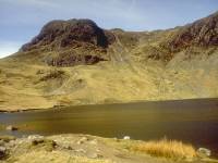
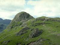
The Langdale Pikes form a compact and highly popular group of fells at the southern end of Lakeland's central ridge. The Pikes themselves, a trio of shapely topknots, are well placed at the northwestern end of Langdale and are thus well seen from the environs of Windermere and Ambleside, two of the principal towns in the area. In fact, they are well seen from most of Lakeland's southeastern approaches, most notably the col above Kirkby Lonsdale on the road from the Yorkshire Dales. The three rocks towers standing high above the valley floor give a truly dramatic impression to the scene and hold a promise of great adventure for those who set out to climb them. Fortunately their ascent is pretty straightforward, but for the mild scramble necessary to attain the summit of the westernmost top, Pike O' Stickle.
In topographical terms the Pikes are really just a cluster of tops, outliers of High Raise, their parent fell. Most folk would assume from the profile of the Pikes that they stand as an isolated group but in fact Lakeland's central ridge sweeps northwards from them with very little drop in altitude. High Raise, at 2500ft the principal summit of the group, stands north of the pikes themselves, a gentle lump of a hill in the midst of a vast sweep of moorland. All the ground to the north of High Raise is covered on the Central Fells page, including High Raise's own outliers of Sergeant's Crag and Eagle Crag - sufficiently far enough from their parent that they are usually climbed from Stonethwaite, to the north.
The other "dull" summit of the group is Thunacar Knott, elevation 2351ft and High Raise's immediate neighbour to the south. It, too, is little more than a bump in the surrounding moorland but it acts as a hub from which the other five fells in the group radiate. Ranged around an arc to the south are the Langdale Pikes themselves: Pike O' Stickle (2323ft), Loft Crag (2270ft) and Harrison Stickle (2403ft), the highest and most dramatic of the three. To the east of Thunacar Knott are Pavey Ark (2288ft) and Sergeant Man (2414ft), barely even qualifying as tops in the true sense but portraying such bold profiles to the facing valleys that they have long been recognised as separate fells.
There are many ascent routes to the Pikes and some most interesting features among them. One of the more dramatic ascents is via Dungeon Ghyll, between Harrison Stickle and Loft Crag, a route that gives grand rock scenery most of the way. Almost as rewarding is Stickle Gill, which climbs to an upland shelf holding the sizeable lake of Stickle Tarn at 1500ft, and which stands directly in front of Pavey Ark's near vertical eastern face. Rock scramblers have two hair-raising routes on this face; Jack's Rake and the so-called Easy Gully. A longer but thoroughly interesting approach comes from Grasmere along Easedale, a route which can either approach Stickle Tarn from the north or can give an easy ascent to the ridge direct via Sergeant Man. Finally, the approach from the west over the sloppy flats of Martcrag Moor can be effected from the col of Stake Pass, reached either from the head of Langdale to the south or Langstrath to the north.
Also included in this page is the valley of Langdale itself, and the
ground to the south; the minor fell of Lingmoor separates Langdale from
Little Langdale, a grand little valley that heads up to one of
England's
most dramatic mountain roads, Wrynose Pass.
|
|
Langdale Pikes, 13th April 1985
An early Spring climb of three of the Langdale summits. |
|
|
Langdale Pikes, 20th June 1993
Sergeant Man, Pike O'Stickle and Loft Crag climbed from Easedale |
Links
![]() The Langdale Web
The Langdale Web
Back to Lake District index page